

After the long, straight, and narrow channels that define the northern end of the Inside Passage, from Prince Rupert to SE Alaska is a final 50-mile expanse of open Pacific Ocean known as Dixon Entrance. Foul weather is frequent, and so are large ocean swells and uncomfortable waves – not to mention fog. We always treat Dixon Entrance with a huge amount of respect, and Kap frets over the weather forecasting here more than anywhere else in our cruising areas. At the north end of Dundas Island are anchorages you can duck into at Brundige Bay, and then again at Foggy Bay once you’re across it – but other than that, if you stick your nose out, it’s pretty certain you’re going to go all the way. If you’re crossing to the north and you’re a slow boat – many full displacement boats only travel at 7 knots, and can’t reach Ketchikan from Prince Rupert – the anchorage at Foggy Bay is used by many – but you’re breaking U.S. CBP laws if you don’t call in to say that you’re on U.S. territory.
It seems like an exaggeration, but we’ve made serious plans to return to SE Alaska every year since 2010. And each year something has happened to frustrate those plans.
We were the closest to achieving our goal in 2010, and of all the years, our problem that year was the most dramatic reason for not getting there. The night before our departure Kap took a nasty header onto her face on the sidewalk at our Anacortes marina while walking Gator one last time before we turned in for an early night. The scrapes and bruises everywhere were the minor problem – the big problem was she broke her wrist trying to stop her fall (it was the hand with Gator’s lead on it and her knee suddenly collapsed as she started to run with him, causing the wrist to be at an odd angle). Landing awkwardly it caused a nasty bone compression at the wrist end of the radius bone, requiring serious surgery to fix it. After recuperation from surgery, we managed to recover our cruising season, but didn’t get any further north than The Broughton’s – with Kap flying home every two weeks on Kenmore Air for physical therapy.
Don’t forget – you can click on any photo in the post to enlarge it.
If you want to see where we are now, or better yet, monitor our route progress as we cruise along, you can click here to go to www.ronf-flyingcolours.com, then click on the Current Location link in the upper right corner of the home page.
Also, this post is more readable in the online version, plus you can read any of the posts back to 2010 from the archive.
As a teaser, make sure you go all the way to the end of this post, for photos and stories about eagles during this summer’s cruising adventures.
Saturday, July 21th; Butedale Cannery to Prince Rupert. We have a lame cat, in a lot of pain, and if we don’t get her tended to as soon as possible we’ll run out of the “happy juice” that’s helping her with the pain. But Prince Rupert is over 100 miles away, so are we going to make it in one long “stretch” day or stop off at anchor at one of the four bays along the way, delaying ZuZu’s visit to a vet. I vote to press on, and in the end Kap agreed.
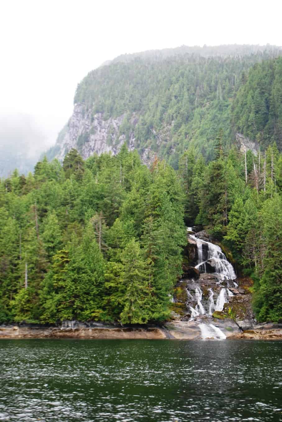
Almost every valley behind the waterline on either side of the channel has a lake that flows out to the channel, producing a hundred waterfalls that are wonderful eye candy for our cruise.
With that decision there was nothing to do but buckle down for a long day, establish a drive/rest schedule to get through the long hours, and keep plodding along at 8 knots for the next 12 hours. Trouble was – and for reasons we’ve not been able to explain – our tide and current tables for this area didn’t match reality. Instead, where she’d calculated our arrival time based on a current of 1-2 knots going with us, we were actually finding a current against us most of the way. If that continued, we’d have a hard time making it all the way to Prince Rupert, and that left us with the unknown about whether we’d have to stop in an anchorage for the night.
Flashback: On our trip through here in 2008 we were following our friends Bucky and Christy in Undoc’d. Suddenly Bucky said on the radio, “There’s a bear swimming across! He’s right in our path!” We trained our binoculars on the dark lump in the water just off their starboard side, and sure enough it was a brown (grizzly) bear swimming across. And it was swimming pretty smartly, passing just off Un’Docked’s stern and in front of us. Before I could grab a camera he was too far away to get a good shot.
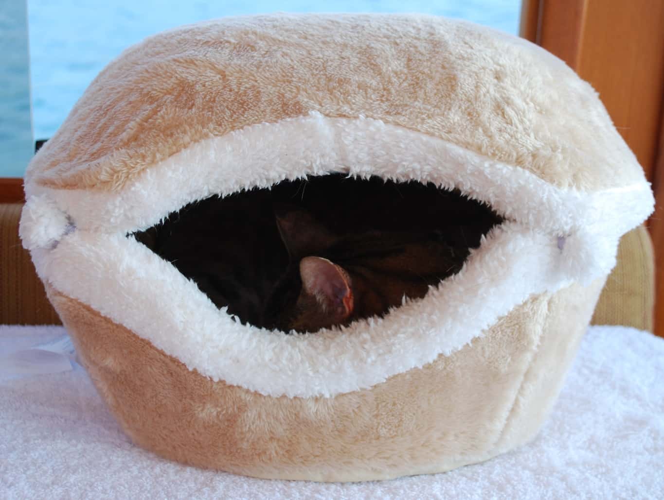
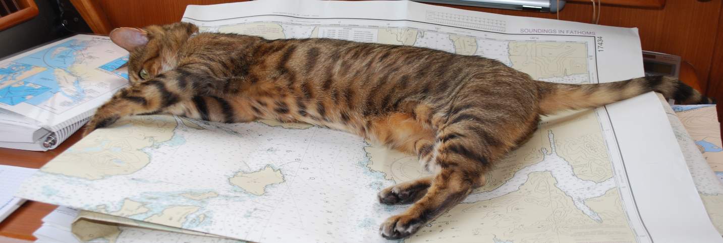
ZuZu spends about half of each cruising day sleeping in her clamshell, and the other half wedged between the windscreen and pilot house dashboard. This is her safe spot and where she goes whenever things get too rough – and when she’s had a bit of happy juice. . .
Throughout the day’s journey, ZuZu slept quietly in her clamshell bed on a perch in the pilot house. Once in a while we’d get a glimpse of her tail sticking out, but only once or twice throughout the whole day did we see any sign of consciousness due to the strong medication. At least it didn’t appear she was in pain – not that we could see anyway.
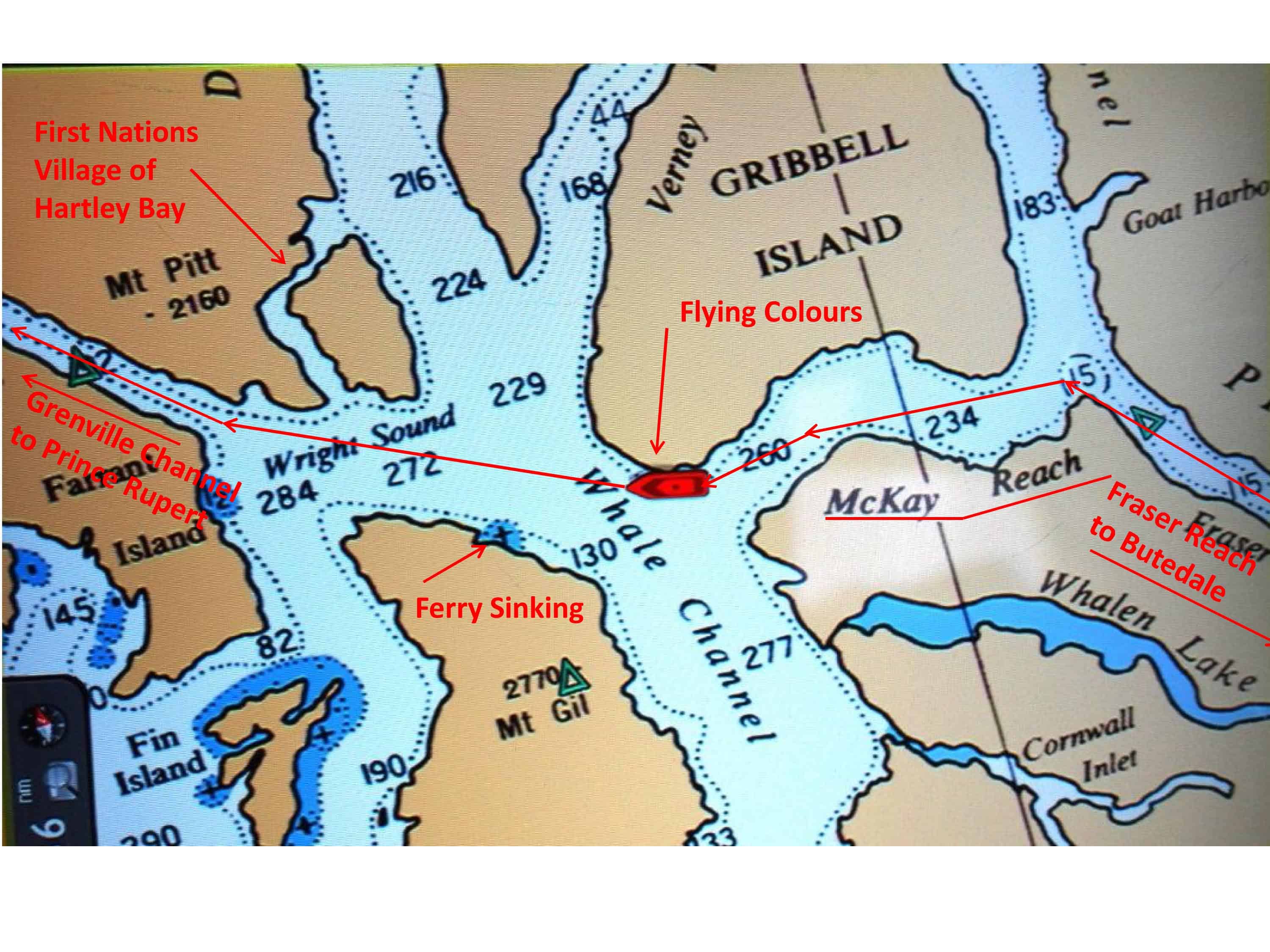
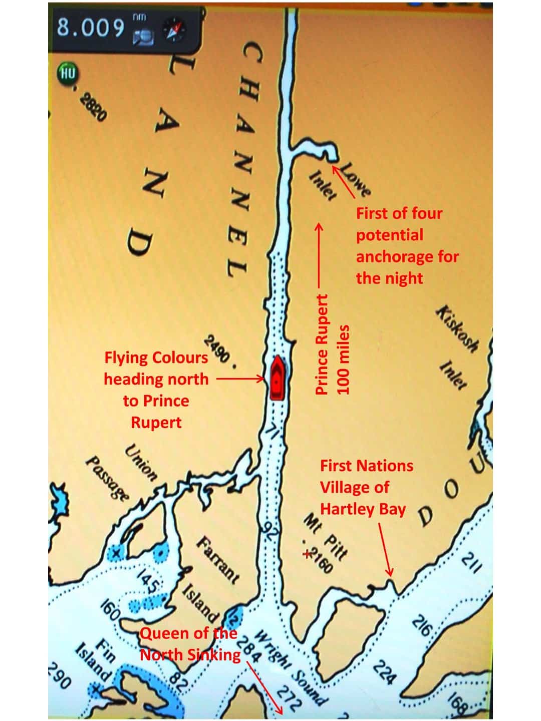
This map shows our route northward across the complicated 6-way intersection of waterways that connect a bunch of channels. The B.C. Ferry that sank here in 2006 was going exactly opposite of our route. By not making the left turn as they left Grenville Channel, the ferry continued across Wright Sound, just missing a direct head-on collision with Gil Island, but rather sliding along the NE tip that juts out from Gil Island, and then running aground on a reef that juts out a mile or so along the coast of the island – then sinking with tragic results.
For the next couple of hours we made our way north on Fraser Reach, with Princess Royal Island on our left. At the end of Fraser Reach we entered an unusual 6-way intersection that leads into a very large sound, and across the top of Princess Royal Island. Our passage through McKay Reach and into Wright Sound was uneventful, but it got a bit lumpy, as the channel that winds westward around Fin Island leads directly out to open water of the Pacific. It wasn’t a problem, but just a bit bumpy (and it was a good thing ZuZu was zonked). The best part of the transit was, we had a short span of cell phone reception as we passed the entrance to the side channel leading north to the village of Hartley Bay (tucked in behind Gribbell Island). It was our first link to the outside since departing Shearwater, and it’s always good. (These days, on outages like that I have upwards of 200 e-mails stacked up to download – at least 150 of them totally junk spam e-mails, maybe 25 of moderate interest, and another 25 that are of actual value.) At the northwest corner of Wright Sound we turned north to enter Grenville Channel, the last long channel before the final open water stretch to Prince Rupert.
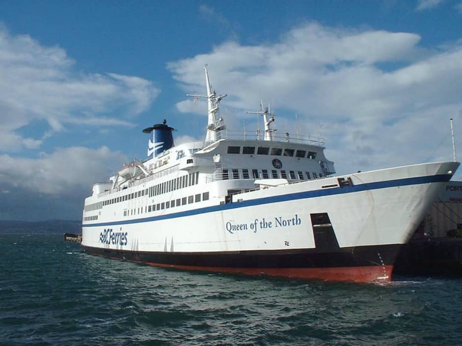
The MV Queen of the North was the B.C. Ferry that struck a reef and sank near Hartley Bay in 2006 with the loss of two lives. She had a passenger capacity of 700 and 115 vehicles, but on the night of the sinking she carried 101 souls. Launched in 1969, she was 375’ long and cruised at 20 knots.
Hartley Bay Ferry Sinking. It’s late at night – 12:25AM to be exact – and the B.C. ferry, Queen of the North, heading south on her every-other-day scheduled run from Prince Rupert to Port Hardy has just exited Grenville Channel into Wright Sound. From Wright Sound there’ll be a sharp left turn into McKay Reach that crosses the top of Princess Royal Island, then a sharp right turn into Fraser Reach (which feeds into the various channels that pass Butedale Cannery and onward towards Shearwater). For some reason – that’s still in dispute today – the first left turn to McKay Reach wasn’t made, and in total darkness it wasn’t noticed. The ferry continued across Wright Sound, just missing a straight-on crash into the northern tip of Gil Island. Her hull snagged the rocks jutting offshore at the NE tip of Gil Island, ripping it open and causing it to sink in over 1,200’ of water. A mayday call was put out on VHF, and long before the nearest Coast Guard vessel could arrive to rescue passengers, a small contingent of First Nations fisherman leaped out of bed and raced across with a fleet of fishing boats to get the rescue started. All but two of the 101 passengers aboard were rescued, and it was later theorized that the two missing passengers were trapped in their car on the lower deck.
The mystery was, what went wrong on the bridge (the driving and navigation station) of the ferry that caused the crucial turn not to be made. The fourth officer was at the helm at the time, and it’s undisputed that the ship’s female Quartermaster was with him on the bridge during this time. It was alleged they were having sex – they had previously had an affair – but they claim they were instead having a serious argument that distracted them. The fourth officer was subsequently convicted of “criminal negligence causing death” and sentenced to four year in prison.
In any case, the small village of Hartley Bay has so far gotten the short end of the stick on the disaster. There were 40,000 gallons of diesel fuel in the ferry’s fuel tanks and 8,000 gallons of lubricating oil aboard (by comparison, we carry 1,000 gallons of fuel and essentially no lubricating oil). In addition to an oil slick that blanketed the entire sound right after the sinking, the wreck is still deteriorating on the bottom, periodically releasing toxins that float to the surface.
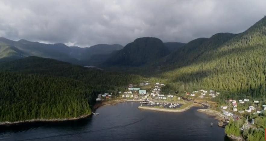
I grabbed this aerial photo from a “screen scrape” of a YouTube video of the Hartley Bay area. Obviously, this is quite a small village.
The Gitga’at First Nations band has been trying for over a decade to get the B.C. government to raise the wreckage to protect the marine environment – which is their livelihood. So far, nothing has been done. When we visited in 2008 a new ferry terminal had just been built, supposedly in appreciation of the assistance the locals gave to the rescue effort that night (a small ferry operates between Hartley Bay and Prince Rupert, and with no roads in the area, this is their only access to the outside world).
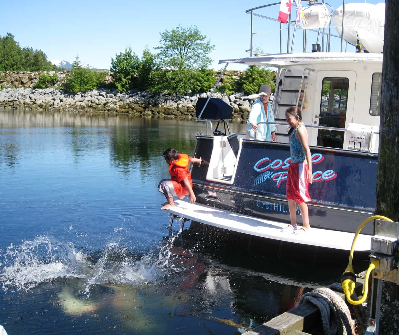
On our 2008 overnight stop in Hartley Bay, several First Nations kids from the village came down to the docks in the evening, and with no prompting from us, asked if they could use our swim step on Cosmo Place as a diving platform. We said sure, and watched with smiles on our faces as they dove, climbed back aboard, dove again, and repeated that for at least an hour. Obviously these kids were used to the cold water.
Inside the village itself there are no roads or streets (so there are no cars either), and all of the houses and tribal buildings are linked by raised boardwalk – and ATVs are the preferred mode of transportation, as is walking. On our overnight stop in 2008 we were extremely impressed with Hartley Bay, mainly the spirit and attitude of the people. We were encouraged to visit the salmon hatchery on a large stream behind the village, and everyone we met on the boardwalk was very friendly, with a big smile and shouts of “Hello!”. At the salmon hatchery the operator enthusiastically showed us the various tanks for the Coho salmon as they progress in age and size. What was very obvious was his disdain of the B.C. Fisheries support for the commercially farmed Atlantic salmon hatcheries in Lower B.C. – and he stressed (with great contempt) that this is the result of appointing a land-based agricultural bureaucrat to head the Fisheries Department.
One of our five computer monitors on the dash is always scrolled out for the big picture view of where we’re going (the most practical reason for it is to give us a sense of where we can cut corners to save time and fuel). Kap always likes to keep one monitor scrolled in very close, as a precaution that we won’t miss seeing a rock or shoal that could spell disaster.
Back to Our Cruise Up Grenville Channel. With our need to get to Prince Rupert, we decided to give Hartley Bay a miss on this trip.
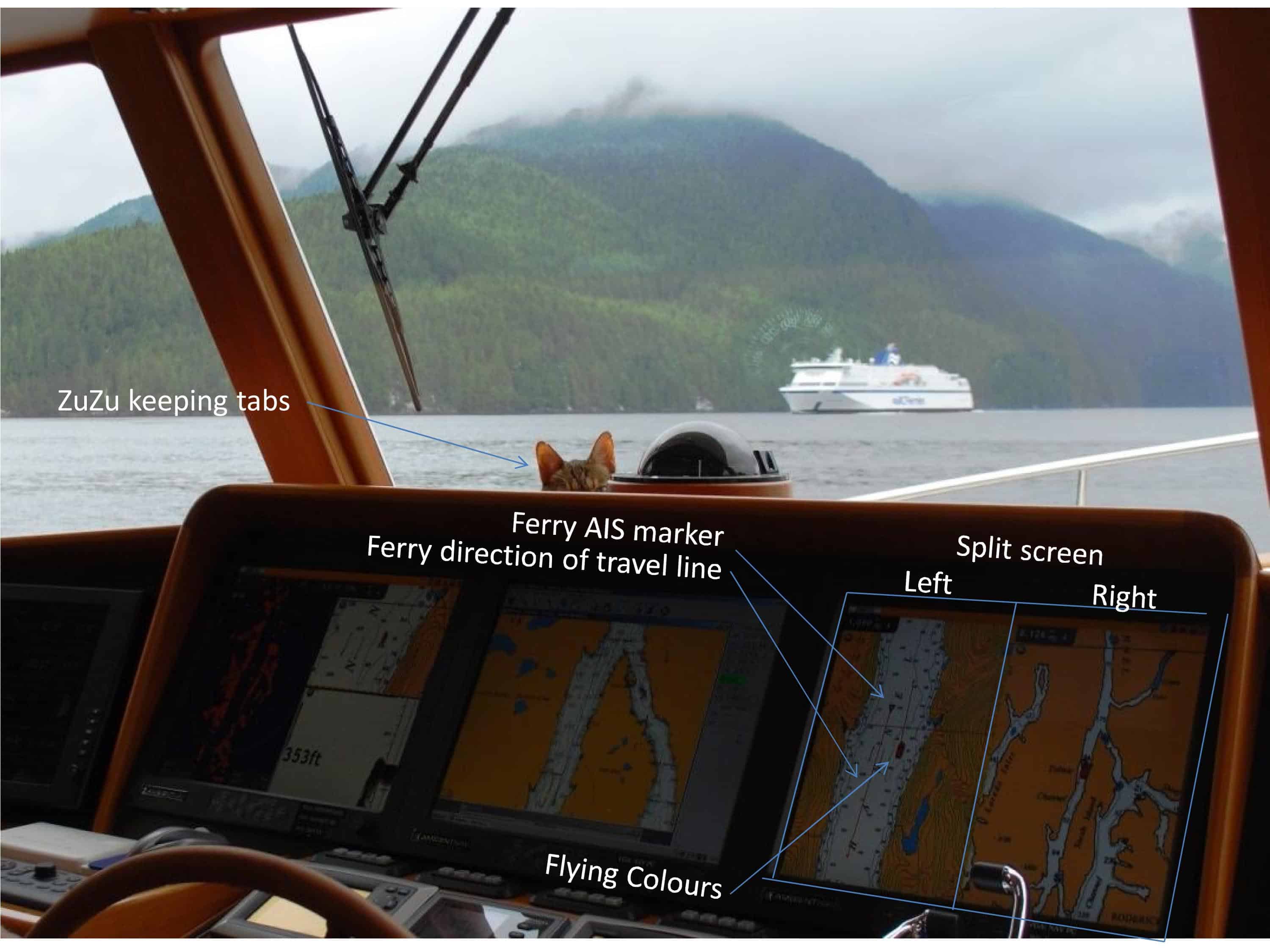
Not long after we entered Grenville Channel we heard Traffic talking to the Northern Expedition, a B.C. Ferry that runs every other day between Port Hardy and Prince Rupert. It was coming towards us, and when she was about six miles out we started to see her on AIS. This photo shows our passing.
We’ve seen the Northern Expedition more than any other vessel so far on our trip. It’s been on this run from Port Hardy to Prince Rupert since 2006, when the Queen of the North sank in a tragic accident just a few miles south of here near Hartley Bay. It must be eerie for the crew as they transit through Wright Sound, knowing that their predecessor is at the bottom, 1,200’ below them.
I doctored up this computer screen shot photo so that I could explain it a bit (and you’ll have to click on the photo to enlarge it). On our rightmost navigation screen, it’s always set up in split-screen mode, with different zoom settings – the right half zoomed way out to show maximum scale; the left half zoomed in to show local scale. On the left half, I’ve pointed out the AIS signal for the Northern Expedition, and both of us seem to be nicely spaced apart (laterally) in the channel. When you look out the window, though, it looks like the ferry is way off on the other side of the channel from us, and a (relatively) huge distance between us. Keeping everything in perspective is an important task in watching the electronic monitoring of what’s going on versus looking out the window.
We know for miles and miles in advance when we’ll be meeting (or being overtaken by a significant vessel, as “Traffic” – the waterways equivalent of Air Traffic Control for commercial jetliners – is talking to all commercial vessels over 70’ about their current location, plus their ETA for their next waypoint. When they’re within 6-10 miles they also show up with their AIS marker on all of our navigation software screens. This time as we approached, Traffic made the following comment on the VHF radio frequency: “ . . . and there’s a nonparticipating AIS vessel, Flying Colours, such-and-such distance ahead”. At first, that sounds rather negative and judgmental about us – referring to us as “nonparticipating”, as if we just aren’t playing by the rules, but in fact, it just means that we haven’t filed a “float plan” with Traffic and they are not monitoring us as they do for “participating” vessels.)

We met this sailboat a further few miles up Grenville Channel. It won’t win any awards for being sleek and beautiful, but it’s probably very functional for long distance cruising. This photo gives a really good impression of how dense the trees are, right down to the water (and how few the "bear beaches" are). The scarf at the top of the mountain behind is a slide that took out trees along a big chuck of real estate as it crashed down the mountain..
With mountains just like this on both sides of the channel, plus having a fairly constant water depth below us of 600’-1,000’, you really get the sense of being in a significant fjord-like valley that we’re cruising in. As we can see on our navigation charts (and confirmed by Vancouver’s soundings over 200 years ago, where the mountains meet the water, their sides continue the same steepness to the bottom, and the valley floor is quite flat. With our depth sounder readings, we can see that the depth below us remains virtually constant for long periods, indicating a very flat floor to the valley. These deep valleys were certainly carved from the glaciers that formed here in the Ice Age, then filled in with water from the channels that lead out to the Pacific.
Mid-afternoon we passed the last two of the duck-in anchorages before we hit the open water to Prince Rupert – Baker Inlet and Kumealon Inlet. I think Kap felt that caution dictated a stop, but with daylight until late in the evening I was of a mind to go on. What complicated matters a bit was that it was Saturday, and even if we did get into Prince Rupert, we’d have to wait through Sunday before any vet would be open. Stopping, though, meant getting the dinghy down after setting the anchor – always necessary when you have a dog that needs to go ashore – and then getting it back up in the morning before departure. After talking each anchorage through, we made the decision to go on.
Finally (and I don’t mean that to sound as if I wasn’t enjoying the day), we reached the northern end of Grenville Channel, where it again starts to widen. And even though we found more and more current against us, and it increased our worries that our reduced speed over the ground would push back our arrival time. In fact, our Nobeltec software was beginning to show a very small reduction (5 minutes) in time. Just as Kap was starting into the open water after the end of Grenville Channel – and feared that it could be rough, we met the Ocean Titan – a Western Towboat tug from Seattle – and knowing that our friend Cap’n Doug had been the skipper on it a month earlier, we thought he might be on it now. We radioed to it and asked to switch to frequency 68 where we could chat. It wasn’t Doug on the Ocean Titan, but the good news we got from the Skipper who answered our call was that the seas ahead weren’t as bad as we feared. That was good news, and it further validated our decision to press ahead with the day. I also telephoned the Cow Bay Marina on my satellite phone to confirm our reservation, giving them our anticipated arrival time, and the young lady said she’d be waiting on the dock to take our lines.
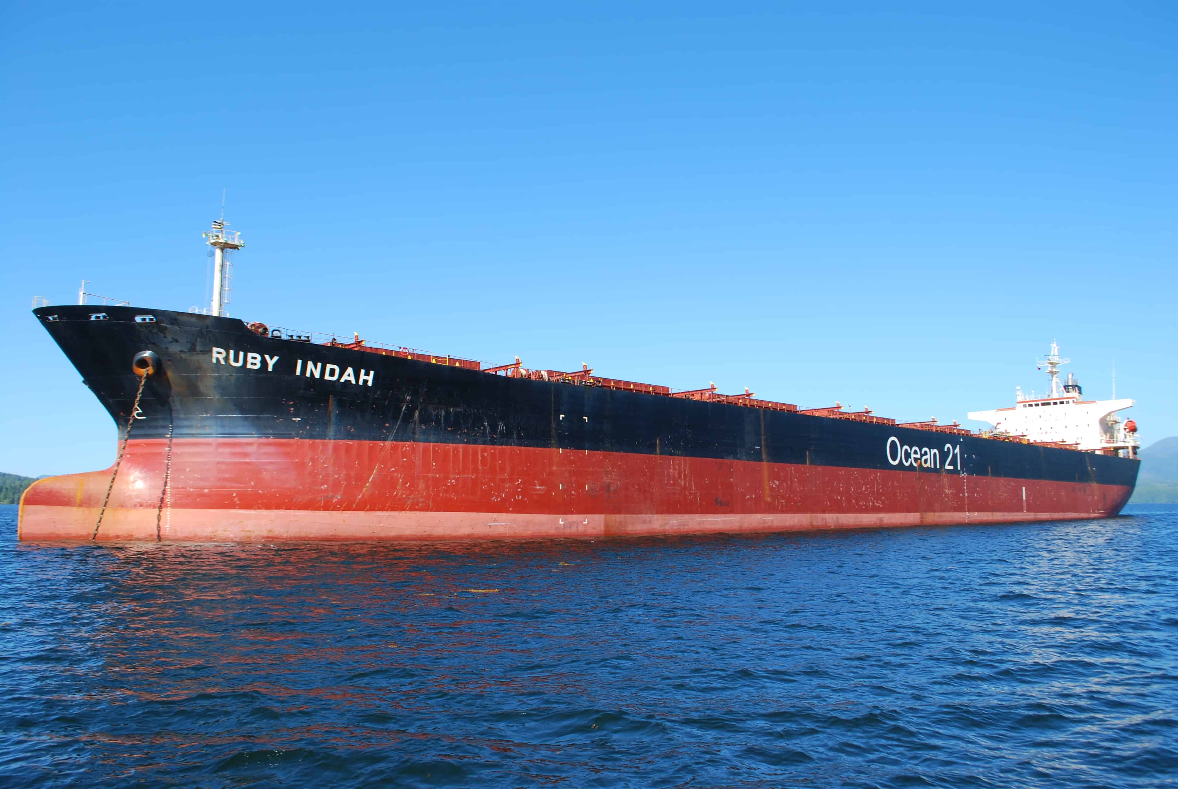
This is the typical grain freighter that we see around Prince Rupert – the Ruby Indah, home ported in Singapore and anchored near to our marina. (And no, I did not use a wide angle lens to make this ship look a mile long - it was just a standard 50mm lens.) She’s obviously empty at this time, as the “bulbous bow” is almost all the way out of the water (a bulbous bow “modifies the way the water flows around the hull, reducing drag and thus increasing speed, range, fuel efficiency, and stability” (Wikipedia article). Way back at the aft end of the freighter, note the small orange “thing” – it’s an escape pod that serves as a lifeboat in an emergency. Often the escape pod is launched from the “mother ship” by a ramp (like a carnival ride), but at close up this one seems to be lowered by a winch.
Just after the open water stretch, we navigated a myriad of small islands, winding our way past shallow (but safe) areas that shaved considerable distance from our day’s overall route. (Kap’s original course line skirted around these islands, but given the lateness of the hour, this change really helped our expected arrival time.
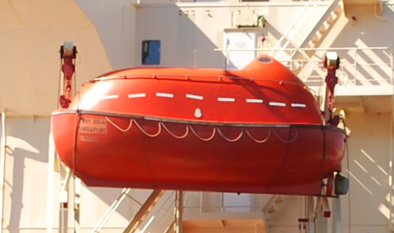
Here’s a closer view of the escape pod, presumably positioned so that crew in the living quarters and bridge have quick access to it in an emergency.
The approach into Prince Rupert is long and slow, with a deep water harbor that services a lot of freighters – container and grain seem the most – plus a large commercial fishing fleet, a cruise ship or two, and a lot of cruisers passing through (to/from SE Alaska). It’s slow because they have a posted Go Slow/No Wake zone that’s several miles from the downtown docks, and they enforce it (mainly for the out-of-area boats like us) with a municipal Port Authority boat (that’s based at the Cow Bay Marina where we were heading).
The enforcer is a small nondescript aluminum boat, maybe 20’ in length, with very unobtrusive markings that hardly show up at 20’, let alone 200’. Kap picked it up running along the shore about a mile outside of the Go Slow point – and she only spotted it because it was transmitting an AIS signal and the boat name indicated in the data block “Port Authority”. It wasn’t long before we were sure it was shadowing us – for whatever reason we hadn’t a clue. As we went by the container facility where the Maersk Line ship was being loaded, the Port Authority boat lagged behind us and we thought maybe he’d found better fish to fry. Another minute later, though, and his AIS signal on our navigation screen sped up and his track was clearly headed straight for us. I discreetly watched him with my binoculars, as he first came up on our starboard stern, and then crossed over our wake to the port side. A moment later he was alongside us, maybe 10’ away from our pilot house doors. He watched us; we watched him. We assumed he was about to make some indication of boarding us – but he didn’t – and the stand-off continued for a minute or two more. We made every effort to not give him any reason to harass us further. Moments later he sped up, veered away from us, and raced across the harbor, ostensibly to catch up with some other villain – and yes, raced at top speed, putting up a wake that their own No Wake zone is supposed to stop (reminded us of cops who use their siren to cross town for lunch). You can bet we watched him with our binoculars, and sure enough, on the other side of the harbor he slowed down in the shallows, all by himself, and just puttered along.
We continued into the harbor at the legal speed. We hailed the marina harbor master, a young woman named Mona, and she directed us to the slip she had reserved for us. As we tied up she gave us a rundown on the marina rules and procedures and we got her to write out the name and phone number of the sole veterinarian in Prince Rupert (plus another that was 60+ miles away in a town called Terrace). The next day was Sunday, so we knew the best we could do was to keep ZuZu doped up on the Buprenorphine – and wait things out until Monday morning when they opened.
After two long days getting to Prince Rupert – a cruise distance we’d normally do in 3-4 days – so Sunday was a total down day. Well, as much of a down day as my Energizer Bunny Captain can tolerate. For my part, I relaxed, dozed, and went through a long stack of e-mails; Kap washed the boat to get off the salt spray of the last several days and talked me into drying the teak cap rails so they wouldn’t spot.
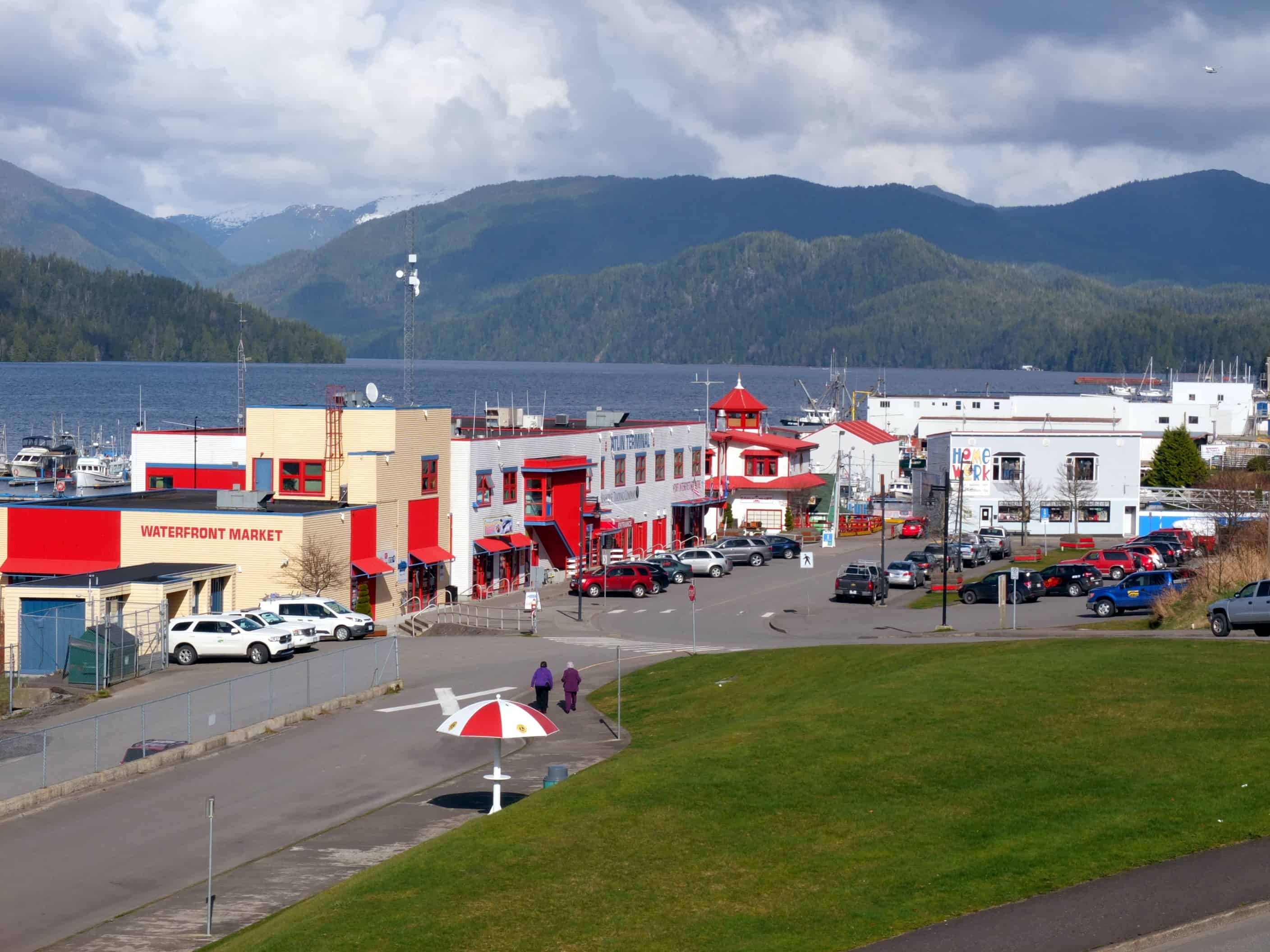
This photo is taken at about the midway point up the hill to the city’s central business district. Cow Bay is a waterfront area that had something to do with cattle shipments long ago, but more recently it was a salmon cannery – and in fact, the white building at center is the old cannery building, built partly on pilings and sticking out into the harbour. It now houses a museum, and on the other side of it is the Cow Bay Marina. It’s a large deep water bay, and some grain ships anchor in it for loading. Directly to the left of the photo is a cruise ship terminal, and a fairly small cruise ship from Vancouver calls in about once a week.
Cow Bay Marina, Prince Rupert. On our stopover in Prince Rupert in 2008, the best marina for cruisers was the Prince Rupert Rowing and Yacht Club, located very conveniently in a waterfront area known as Cow Bay that long had a salmon cannery. The cannery building is still here, but now turned into a museum, and at the foot of the old wharf is the new Cow Bay Marina – where we decided to moor this time.
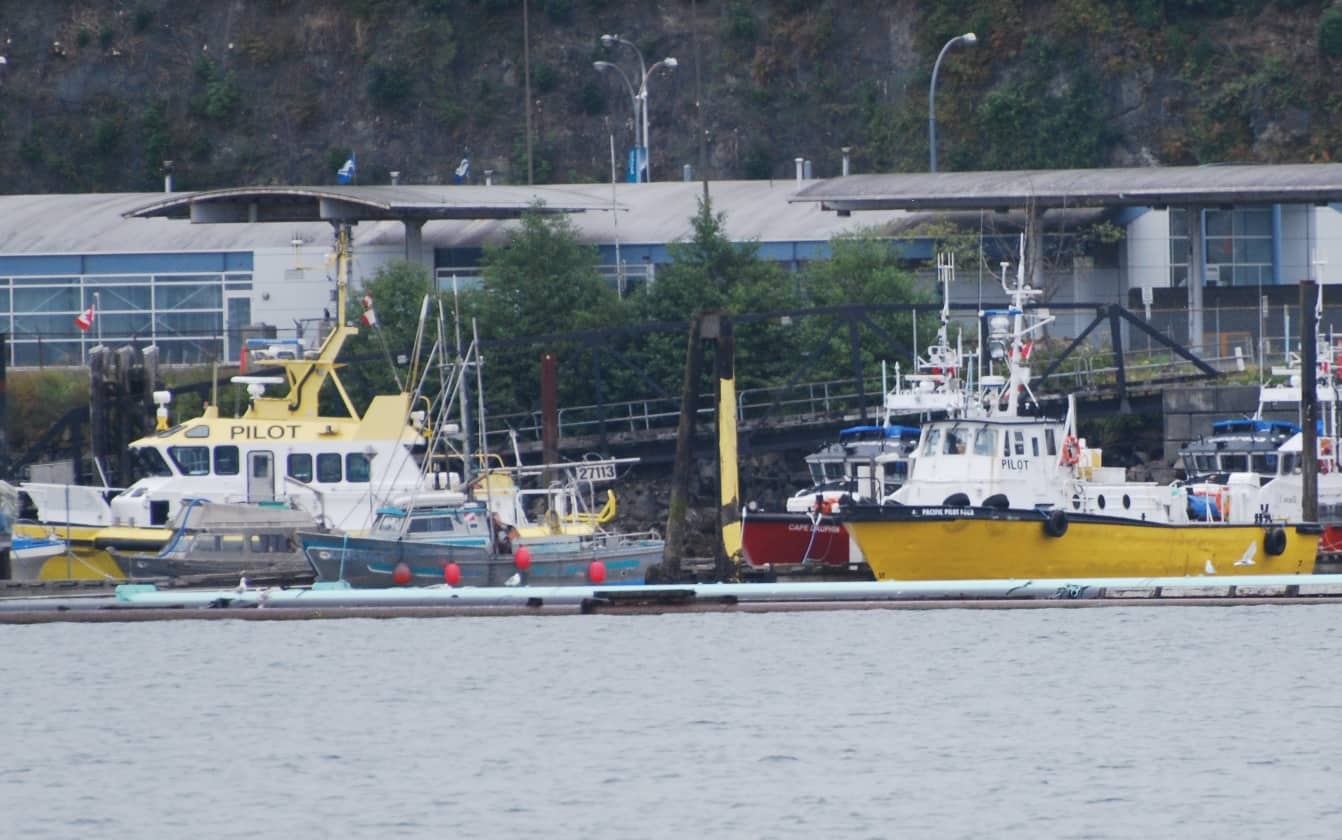
In 2008 when we were departing Prince Rupert on our route south, we had dense fog that gave us virtually no forward visibility (it looked fairly good at the dock, but closed in around us within a few minutes). Just as we approached a harbor channel navigation red buoy, Kap suddenly spotted a fast-moving radar blip to our right and stopped us dead in our tracks. Seconds later a pilot boat exactly like the yellow one in this photo crossed our bow going at least 20 knots, not 20’ ahead of us (in incredibly dense fog). (About all I could see was the large word PILOT on the side.) The idiot had apparently mistaken our blip on his radar screen for the buoy and was “turning around us” to return to his base. Not only did he come incredibly close to smashing into us, but his wake completely buried our bow in the water. I wish like hell we’d followed him and reported what he’d done, but we were just too green to do it in those days.
Monday morning I called the vet’s office – and I didn’t like what I heard: “We don’t have any openings this entire week.” The desk person barely gave me the time of day, and basically told me they weren’t accepting any new “clients”. I was incredulous – a town of 12,000 and they only have one vet!
I waited a few minutes, then called back. “I have an emergency with my cat – it looks like she dislocated her shoulder or has a broken bone.” Nothing doing – they wouldn’t budge on getting her in, even for a declared emergency. I asked what people in town do when they have an emergency and was told that they either drive the 60 miles to Terrace, or an even further 60+ miles beyond that to Kitimat – that they each had a single vet clinic. I was dumbfounded. We obviously didn’t have any way – other than renting a car – to get ZuZu to either of these places – but I took down their telephone numbers and called the one in Terrace. An answering service intercept in Terrace told me that the vet was away on holiday for two weeks, so Kitimat was my only bet.
In desperation I called the vet clinic a third time, and to my surprise the head nurse who answered the phone this time said they could get ZuZu in if I came right away and dropped her off for the day – that they could possibly look at her in a spare moment (but couldn’t guarantee anything). Kap and I scooped up everything I’d need – her soft-sided travel Sherpa, her meds (Meloxicam and Buprenorphine), and her shot records. I immediately called a taxi for pickup at the marina, and headed to the top of the dock to wait.
Of course, the vet clinic was on the far western outskirts of town (along the highway to Terrace) and the one-way taxi fare was C$20 (US$15). Because I’d gone around the front desk staff, my reception on arrival wasn’t the greatest, but after waiting almost an hour for other pets to be checked in, they gave me some paperwork to fill out and collected ZuZu. As usual when she goes anywhere near a vet clinic, she was fit to be tied, and screaming at the top of her lungs. Since I had to leave her for them to handle when they had time, I explained how difficult she can be, even in getting her out of her Sherpa, but they said, “Oh, we handle stuff like that all the time.” Yeah, right. They’ve never seen ZuZu at the vet…..
After my C$20 taxi ride back to the marina all we could do was wait. Within an hour they called to say that ZuZu was totally unmanageable and they asked for authorization to lightly anesthetize her for the examination and x-ray. I said sure – but then they told me I’d have to return to sign the authorization form, as they couldn’t/wouldn’t accept an electronic signature. So it was another C$40 taxi ride back out to sign the paper.
Mid-afternoon the vet clinic called and said that the exam was complete, ZuZu was awake from the anesthesia, but that the vet wanted to discuss with me in person the results of what she found – and could I return at 4:45PM, just before they close at 5PM. That made us nervous, but I said I’d be there. Another C$40 taxi ride, and I may not even be able to bring ZuZu home – but what else could we do.
After all the drama with ZuZu, once we got her out of the vet clinic, she’s acted like her old self – even playing on the chart table with her left shoulder and leg – where she’s supposed to have arthritis that makes her limp. It could be selective, as a way to let us know that she doesn’t want to be on the boat.
On my return they got me into a face-to-face meeting with a very nice vet, who immediately brought up several x-rays on her computer screen. She showed me ZuZu’s shoulder, then her left front leg and foot, and then the rest of her body (even pointed out a stool that was working its way through) – and then said, “I can’t find a thing wrong with her.” She also said that ZuZu was so out of control before the medication that they had no idea how to even see visually what her problem might be, and once they got her anesthetized, the only exam they could get was the x-ray. Maybe now with me here I could get her to walk a bit and they could observe what her problem might be. In an exam room I got her out of the Sherpa – without much problem at all – and she walked and walked around the floor of the exam room. With me there, ZuZu let the vet physically examine her and she could find nothing but the arthritis in her shoulder. Other than that, there was no indication of the injury that we’d seen for the past several days. After lots of discussion, the conclusion was that ZuZu’s problem was most likely soft tissue damage from the fall on the boat, and maybe all the downtime from the Buprenorphine had healed it up. I paid C$240 for the day’s visit to the vet clinic, scooped ZuZu up, and called for a taxi back to the marina.
Whew! What a long story for such a nothing burger. (And since then, ZuZu’s shown no indication of any problem other than the arthritis….)
But a good outcome of it was a new freedom to head north to SE Alaska, at least as far as Ketchikan. Quicker than you can blink an eye, Kap checked the weather and sea conditions across Dixon Entrance for the next day – Tuesday, July 24th – and we made preparations to depart at first light.
Across the dock from us we got to know a couple from the Seattle area on a boat similar to ours named Cape Fairweather (an older DeFever 49 that has lines very similar to a Fleming). They cruise to SE Alaska almost every summer, and Kap was eager to talk with them about weather forecast details to listen for about Dixon Entrance, the 50 mile stretch of open water that we’d have to cross soon after departing Prince Rupert. When we learned of their departure time in the morning we decided to follow them, particularly since the first part of the cruise would take us through Venn Passage, a very twisty and shallow area in a cluster of small islands that would cut at least an hour from our cruising time.
Fog! The bane of our existence on the water. We hate departing in fog, but this could last for days. By now, our radar skills are good, and while that doesn’t bring our risks down to zero, it keeps it at a manageable level.
Tuesday, July 24th; Cow Bay Marina, Prince Rupert to South Bar Harbor Marina, Ketchikan, AK. Wouldn’t you know it! After no fog for the time we’ve been at Prince Rupert, we awoke to thick fog for our departure. Almost immediately the decision is made by us and the couple on Cape Fairweather – that it’s too risky to go through the shortcut called Venn Passage that would reduce our cruise time by an hour. The fog is going to slow us down too, so we know already that it’s going to be a long day.
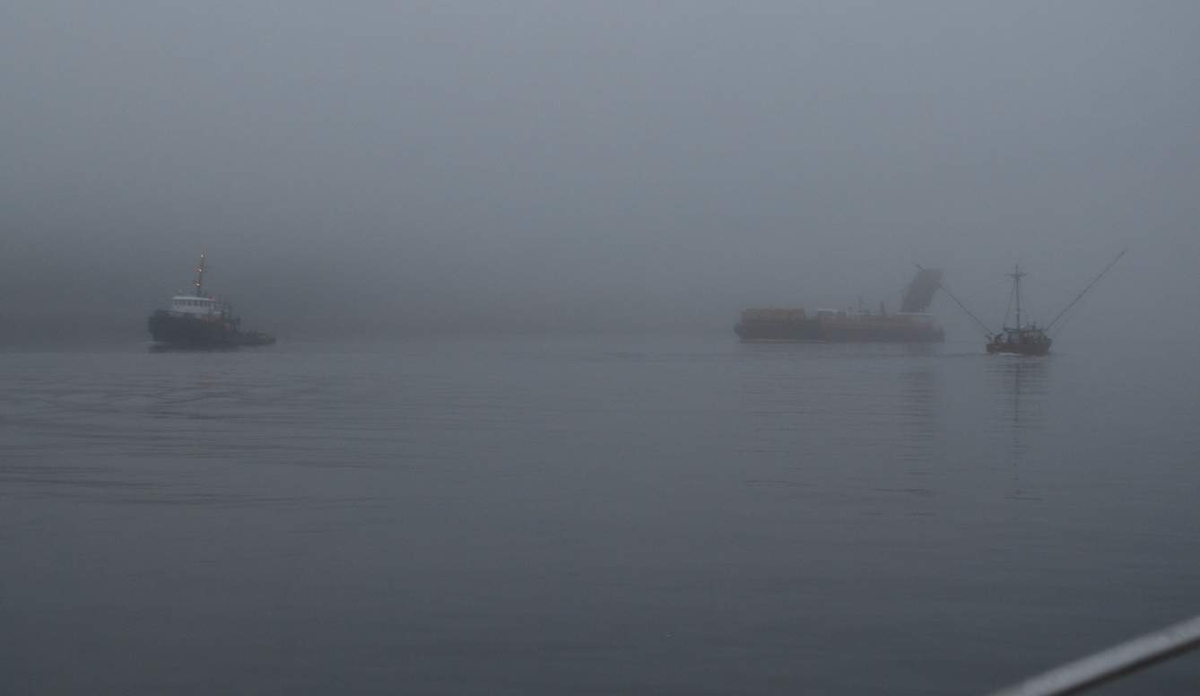
This is what "less than 1/4 mile visibility" looks like. Just after the container port at the entrance to the harbor there’s a fairly narrow channel, with navigation buoys on each side to guide us, but in the fog they aren’t visible until you’re actually at them (although they show up on radar). Right on queue, we are forced to overtake a slow fishing boat, and both of us are meeting a tug towing a barge. You just hope there isn’t an idiot like the pilot boat driver our here.
Right on queue, we are forced to overtake a slow fishing boat, and both of us are meeting a tug towing a barge. You just hope there isn’t an idiot like the pilot boat driver from 2008.) On our right is Digby Island, and once we pass the south tip of it we’ll be out in Chatham Sound where we’ll turn right and head north. We’re in open Pacific Ocean waters for a bit, and luckily we just have 4-5’ swells to contend with – well, except for a mysterious cluster of about 100 closely-spaced fishing buoys in a random pattern – and we’re in the thick of them before we hardly know it. Cape Fairweather has steered outward of them and we wonder if he knows something we don’t – and if he does, why didn’t he warn us of them on VHF? Through a lot of jigging and jagging we manage to miss them, and sure enough after we’re through them the guy on Cape Fairweather tells us on the radio that, indeed, he was aware of them and thinks they’re part of an experimental shellfish farm. Duh! We wish he had mentioned it earlier.
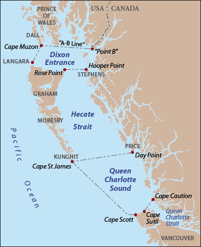
Dixon Entrance is the trapezoidal-shaped outline. Prince Rupert is located just below the word Stephens, and Ketchikan is just above and to the right of the word Prince at the top. The so-called A-B line shown here is the disputed international boundary line between the U.S. and Canada. In 1903, arbitration between our two countries established that line across the top of Dixon Entrance as the “maritime boundary”, and Canada claims it’s therefore the international boundary (and therefore, also marks territorial waters), whereas the U.S. says, no, it just marks the division of the land masses between the two countries – and the U.S. claims the international boundary at the mid-point of Dixon Entrance. (Give Trump another year and he’ll try to start a war with Canada over this…..)
I had hoped to get a good photo of a very picturesque lighthouse station as we passed Dundas Island, but not only was the lighthouse totally obscured by the fog, so was Dundas Island on our left, It looks like we’ll be heading out into Dixon Entrance in the fog.
As we passed the northern tip of Dundas Island we were still in the fog, and we heard a couple of boats on the radio that were coming out of Brundige Inlet and heading south after spending the night at anchorage. Kap raised the possibility of ducking in there to wait out the fog, but after a discussion we decided to press on. By now, since Cape Fairweather was a displacement hull boat – and therefore with a top speed of about 7 knots – we had outpaced them, and even if the fog lifted we wouldn’t see them again today. We were making 8 knots in the fog.
Once in Dixon Entrance, the seas became decidedly rougher, but not terribly so. One nice thing about fog – you only have it if there’s no wind (or little wind), and in this case, the lack of wind kept the seas manageable – but it’s a damn long time to have one set of eyes glued to the radar screen and the other watching out the windows to see that we aren’t about to hit something we might have missed on radar.
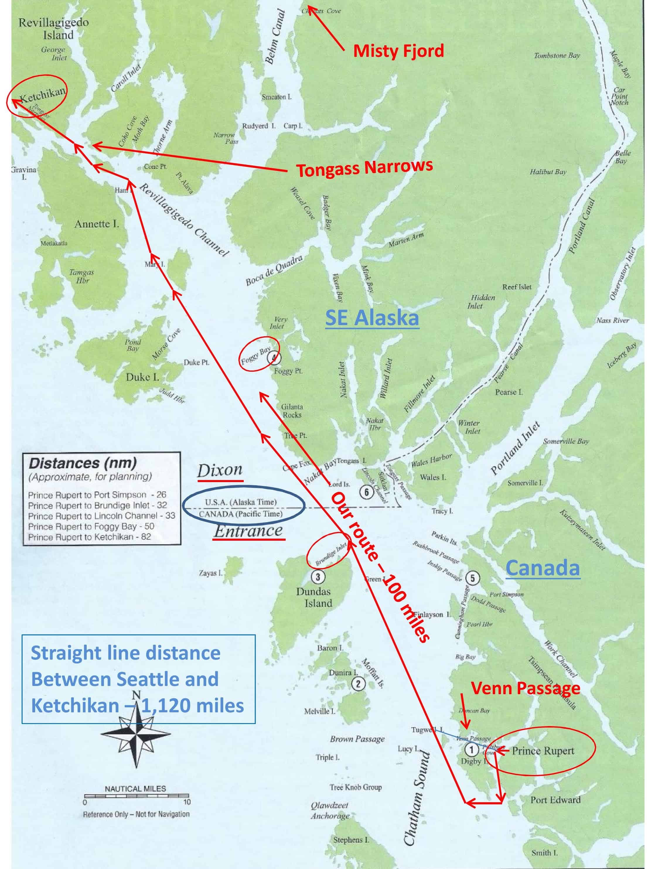
Here’s a more detailed map of our route from Prince Rupert (at #1) to Ketchikan (top left corner).
At the point where our navigation software indicated we were crossing the international border between Canada and the U.S. (the U.S. considers it halfway across Dixon Entrance), I saw that we had AT&T cell phone coverage – and a fairly good signal too – so I called the 800-number for U.S. Customs and Border Patrol (CBP) to see if we could clear Customs via Nexus. I was told very politely that Nexus clearance into the U.S. only works for crossing into the Lower 48, and was given the Ketchikan CBP number to call. I called and got an extremely friendly guy, who explained that they don’t do Nexus clearances, and that they have a near-100% boarding policy at Ketchikan upon arrival. But, since he had me on the phone right now, he’d be happy to take down all of our clearance stuff (passport numbers, boat id, pets on board, liquor, currency limitations, etc), and then when I called in once we were at our moorage in Ketchikan, they’d decide if they’d need to board us or not (they didn’t, and we were happy).
Finally, we were in the shadow of Duke Island – and the fog began to lift (at #4 on the map). It was now coming up on 3PM, and we felt as if we’d had blinders on for 30 hours, and not the eight hours that it had actually been. From there it was just a nice walk in the park to angle left into Revillagigedo Channel (pronounced rev’-ee-le-gig’-a-doe) – and also the name of the island that Ketchikan sits on. Ketchikan is about halfway up the west side of “Revie” (as the locals call it), and we arrived about 4PM.
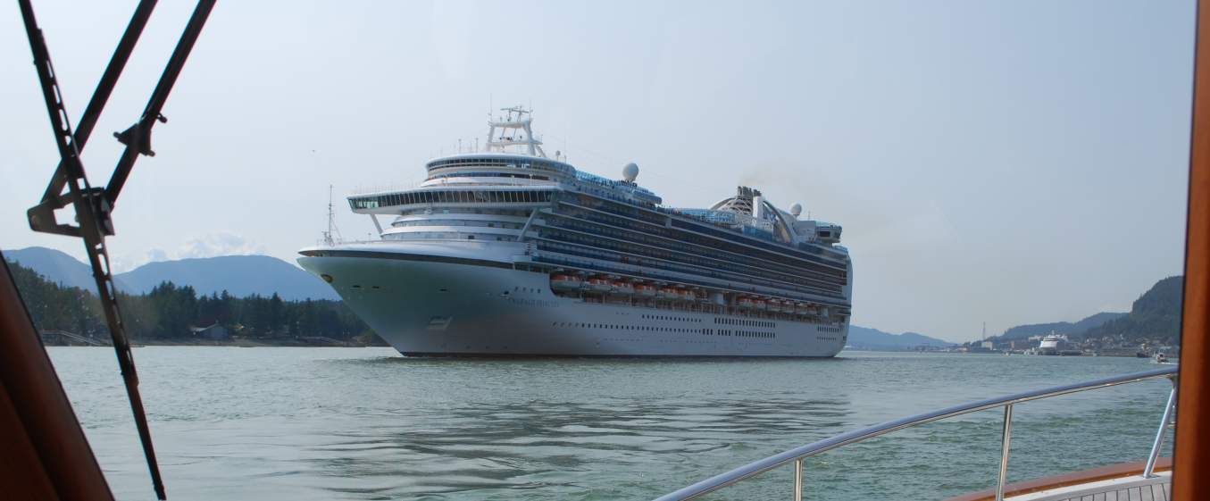
Meeting this cruise ship was our welcome sight to Ketchikan – and there’s another one back at the docks also departing. (For a story about the Bridge to Nowhere that I’ll describe in a couple of paragraphs, take note of Gravina Island opposite Ketchikan) All of the marinas in Ketchikan are commercial boat marinas, municipally-owned and operated, and for the most part they are “hot-berthed” – meaning that many of the boats don’t have permanently assigned slips, it’s first come-first served, and commercial fishing boats take precedence over pleasure cruisers. (There’s probably a large difference in moorage cost/ft, but nothing about that is ever mentioned, and that’s OK with us.
Several miles out, I called Ketchikan Port Authority Harbor Master on VHF, identified us as Flying Colours, our length, and that we needed 50A dock power – and we were requesting moorage at the Bar Harbor Marina – South. There are various other marinas closer to downtown Ketchikan, but the last time we were here it was overshadowed by the cruise ships – and we intentionally stayed about a mile and a half north of town at Bar Harbor Marina (separated by a North and South Section, and the boats of our size are usually assigned to the South). This is also where the only large grocery store in town is located – quite a good Safeway – and it’s only a 5-minute walk from the top of our dock. We were happy they had space for us, and we were assigned to Dock L, slip 42.
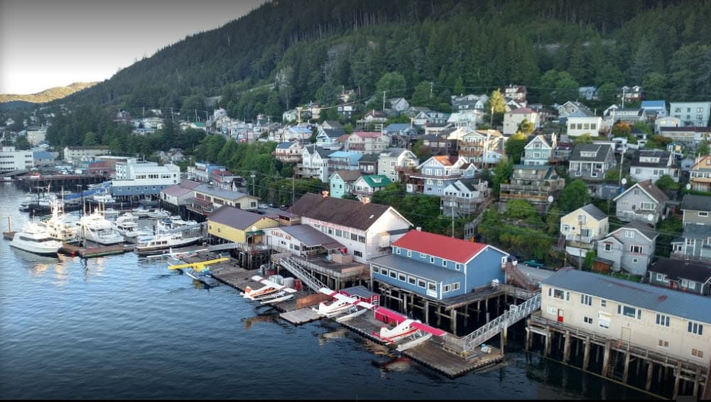
This is a good aerial photo of Ketchikan that shows just how small it is (it’s a photo I cadged off the internet). It only shows the northern half of town, but it gives a good understanding of how the town is hemmed in along the water by the mountains. All day long the fleet of floatplanes roar on take-off and landing, ferrying cruise ship passengers on flightseeing trips, mainly across the island to get a close-up of Misty Fjords. The main drag of Ketchikan is on the opposite side of the wharf buildings in the foreground, and two or three residential streets run along the hillside for the houses. Our marina is just beyond the multistory white building at the extreme far left of the photo. The line of moored cruise ships begins just after the extreme right of the photo. At first glance it’s pretty amazing how busy the main street is – until you realize how many cars there are in town, with nowhere to go but up and down the main street.
You pass downtown Ketchikan on the way to our marina, and we got a waterside view of the changes since 2008. Then, there was room for a maximum of three cruise ships – now it’s seven, and they are the really big ones, 4,000-5000 passengers! One day while we were in Ketchikan we decided to have lunch in town, and boy what a mistake! From our marina you can’t see how many cruise ships are in town, and when we got there we could see that it was six of the really big ones. The streets were clogged with passengers – and barely passable. We were really surprised to find a single table available in a tiny pizzeria, and that was probably only possible because everyone planned on eating back at the ship.
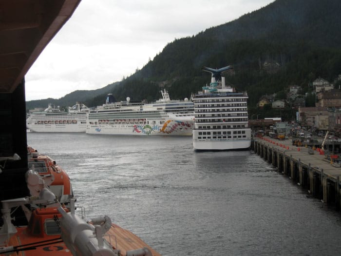
I also cadged this photo from the internet, and it’s obviously taken from a cruise ship, showing four more cruise ships ahead of it, and room in between for at least one more. Imagine the number of people these cruise ships disgorge – into the streets of a small city of barely 8,000 people, with a main downtown area that’s less than three blocks long and two blocks deep. In my estimation the cruise ships have completely destroyed the small cities of SE Alaska like this – all except Wrangell and Petersburg, which have both agreed not to allow cruise ships, and last we heard Sitka only allows a small cruise ship.
It’s almost like walking through Disneyland on its busiest day of the year – and the atmosphere matches it too. We picked up the couple of items we needed and head back to Flying Colours as fast as we could – and that was our one big visit to the city in five days! For the 20,000 cruise ship tourists in town on the busiest days it may be an interesting place to visit, and I would say the same about any part of it outside of the downtown, but I could do without the changes that have taken away the charm of an old fishing village. (On future cruises north to SE Alaska we don’t have any option for bypassing Ketchikan, as it’s the required first port of call for clearing Customs, but it means we’ll likely spend minimum time here and quickly head north (and hope that cruise ship passengers haven’t inundated all of the other cities.
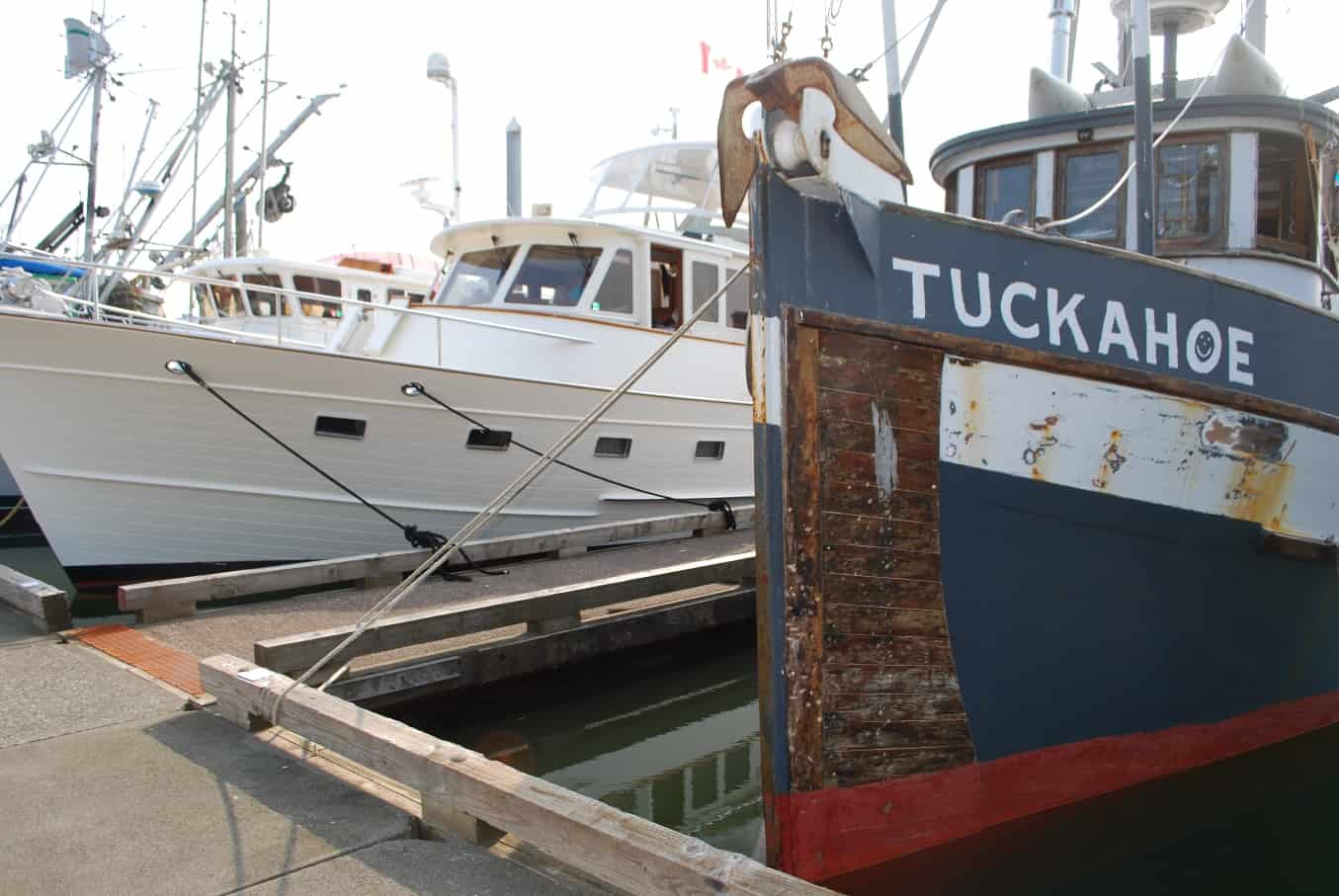
Flying Colours safely moored at Bar Harbor Marina - South, next to the commercial fishing boat, Tuckahoe.
When we pulled into our slip, though, it wasn’t a 60’ slip like we assumed it to be, and Flying Colours stuck out at least 6’ past the end of the dock (and the dock itself was in pretty shabby shape). At most marinas a boat isn’t allowed to stick out – causes problems for other boats coming and going – but not here, as when we radioed the harbor master he said not to worry.
 We were surrounded on all sides by interesting boats – which is definitely the allure of SE Alaskan marinas that were mostly made up of commercial fishing boats. The Tuckahoe arrived in her slip on our port side just moments after we arrived, and we started off with a good chat with him. The owner came down to the dock almost every day from then to do some work on the boat – and boy, did it ever need it. Turns out, the owner’s originally from Seattle, a graduate of of UW, and moved to Ketchikan many years ago to escape – from what, we never learned. Nice guy.
This pair of photos is a good study in contrast – Flying Colours and Tuckahoe. The Tuckahoe is a bit rattier than most – and I never could figure out the multitude of pullys in the frame contraption near the stern – each seemed to have fishing line in it, but how they worked is beyond me. When the guy unloaded his salmon box at midship we saw that whatever he’s doing . . . it works. He must have had 30 or 40 good-sized salmon in it.
Our neighbor on the other side with the sunken Selene that he’s restoring, told us this used to be his boat, but when he got the Selene he sold this little work in progress to his best friend at work. What’s interesting about it is, he built the hard-sided fly bridge enclosure, and the sliding side windows that he installed in it are from a Greyhound bus at the local junk yard. Now that’s ingenuity!
The boat on the other side of us is a privately and locally owned cruiser. It’s a 53’ Selene, which is quite similar to our Fleming. But it had an interesting history and the local owner told us all about it in a very lengthy conversation one evening. It was purchased by a couple from Washington State, and on their first year cruising to SE Alaska they hit a rock and it sank (partially sank, but he said it filled the engine room and the salon with salt water). The owners took the insurance money and . . . whatever. The guy who now owns it bought it for salvage from the insurance company – he said $80K – and spent the next several years restoring it from all the salt water and rock damage. From 15’ away it looks quite good, but that’s as close as we got to it. Given that his previous boat is the one in the accompanying photo, it might not be as spiffy as we thought at first glance. He loves this boat, though, and couldn’t stop talking about how wonderful it was.
When you’re this far north the sunsets come really late – my camera shows the time on this photo as 10:33PM and the sun isn’t quite down yet. When we were about 20 miles south of Ketchikan on the cruise in, we heard a boat calling the marina for moorage – it was named Misty One - and you can see that name on the stern at the dock in the photo. That boat owns the slip next to us in Anacortes, and every year the couple who own it cruise to SE Alaska just to fish – and now it’s docked one dock away from us here in Ketchikan.
The Bridge To Nowhere. You’ve probably heard about this bridge . . . but I’ll explain about it anyway because it was to be here in Ketchikan. The Ketchikan airport – second largest and busiest in Alaska – is located across the Tongass Narrows from Ketchikan, and anyone flying in or out of the airport has to get across the Narrows via a ferry that crosses every 30 minutes – every 15 minutes during peak tourist season (and the charge is $6 for a foot passenger and $7 with your car). Instead, there was a proposal for the federal government to spend $398M for a bridge that would be as long as the Golden Gate Bridge, and as tall as the Brooklyn Bridge – and the reason for this is, the Tongas Narrows is the major section of the Inside Passage through SE Alaska that links all of the other cities, including super-tall cruise ships and barges like the Pacific Titan tows. Why the reference to “nowhere”? The entire island of Gravina has a total of 50 residents, and with Ketchikan having a population of 8,000 it would represent an incredible waste of money. But Governor Sarah Palin, Senator Ted Stevens, and a bunch of other Alaskan politicians wanted it, and they were determined to get it. Luckily Congress came to its senses and canceled funding for it in 2005.
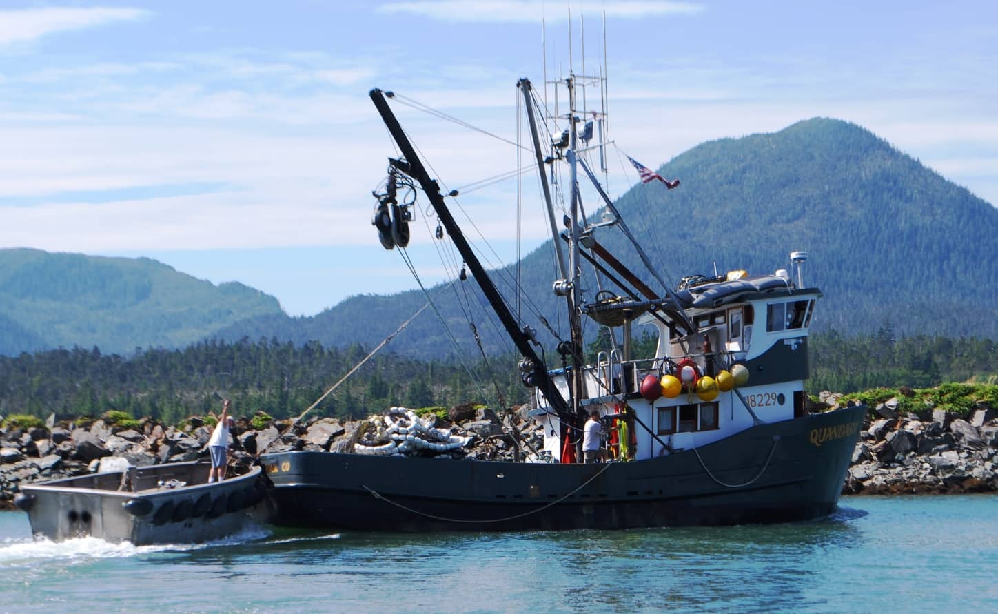
Throughout our stay at Bar Harbor Marina it filled and filled with seiners – because there was an “open day” scheduled in nearby waters for seine fishing. Here’s a seiner heading out the night before the open, and is about to haul the “little boat” aboard the stern of the main boat. The little boat is nothing but an aluminum tub, with an inboard engine that’s totally unmuffled – therefore, incredibly loud – and the driver stands up in it because there’s no seat.
On our trip north in 2008 we were totally flummoxed by the differences between seiners, gillnetters, long liners . . . whatever . . . but because the seiners are by far the most common, at least we’re getting to know them by sight, and can anticipate what they’re going to do (and how to spot them) when we encounter them on our cruising. When a seiner is ready to deploy the net, the little boat is dumped into the water, and “anchors” the end of the seine net – where the net is maybe 10’-12’ wide (i.e., it will hang as a curtain down in the water) and it’s kept on the surface with a string of white floats – which you can see all piled up in the stern of the main boat. The main boat will then drive in a circle, letting out netting all around that circle using the overhead “power block” that you can see as a boom in the photo. When all the netting is out, the main boat will begin drawing the net in like a purse drawstring, closing the circle ever and ever smaller. The fish that are captured are then brought aboard.
On our last night in Ketchikan I was taking our garbage up to the bin at the head of the dock when I spotted the Pacific Titan with her container barge in tow passing by our marina on the way south. I snapped this picture with my iPhone in the evening’s last light. You can barely make out the yellow/blue hull colors of the Pacific Titan, and close behind her the 6-high stack of containers on the Alaska Marine Lines barge.
Pacific Titan – Tug and Tow, Seattle to SE Alaska. On our last afternoon in Ketchikan our old friend, Cap’n Doug Myers pulled into the Alaska Marine Lines (AML) dock next door to the north section of the Bar Harbor Marina where we were moored. On one of my early morning walks with Jamie a few days earlier I had stopped into the AML receiving office at the wharf and asked if the Pacific Titan would be stopping in and was told he’d be here late Friday afternoon on his run south. I subsequently texted him of our whereabouts and he suggested maybe he could pop over for a few minutes to see us on Flying Colours after he loaded containers on the barge (when they arrive at each port, the Skipper and First Mate each drive a huge fork lift in a mad scramble to load or unload containers on the wharf – we’ve never understood how strict maritime union rules allow that to happen, but it works wonderfully well given the unpredictability of their arrival times).
When Cap’n Doug arrived, though, he texted again that his schedule was very tight, as he had to be heading south as soon as possible and only had two days at home and then had to head north again on another run. We agreed to meet for dinner and catch up on our mariner’s stories when we were both back in the Seattle area. (See my July 25, 2014 post, titled House Bank – Depositing Boat Units for a story and photos about meeting up with Cap’n Doug in this same Ketchikan marina in 2008 when we took Cosmo Place to SE Alaska. There’s also a good story there about Ketchikan’s Arctic Bar – and the home of the Happy Bears – where we spent a raucous evening at a benefit dessert auction, and our friend Bucky Wood on UnDoc’d bid on and won seven (!!) pies for an admirable sum of money.)
I later got another text from Cap’n Doug saying that as he passed by he’d spotted our Canadian courtesy flying high on our VHF antenna, plus our two large satellite TV domes – which aren’t very common in a commercial fishing boat harbor.
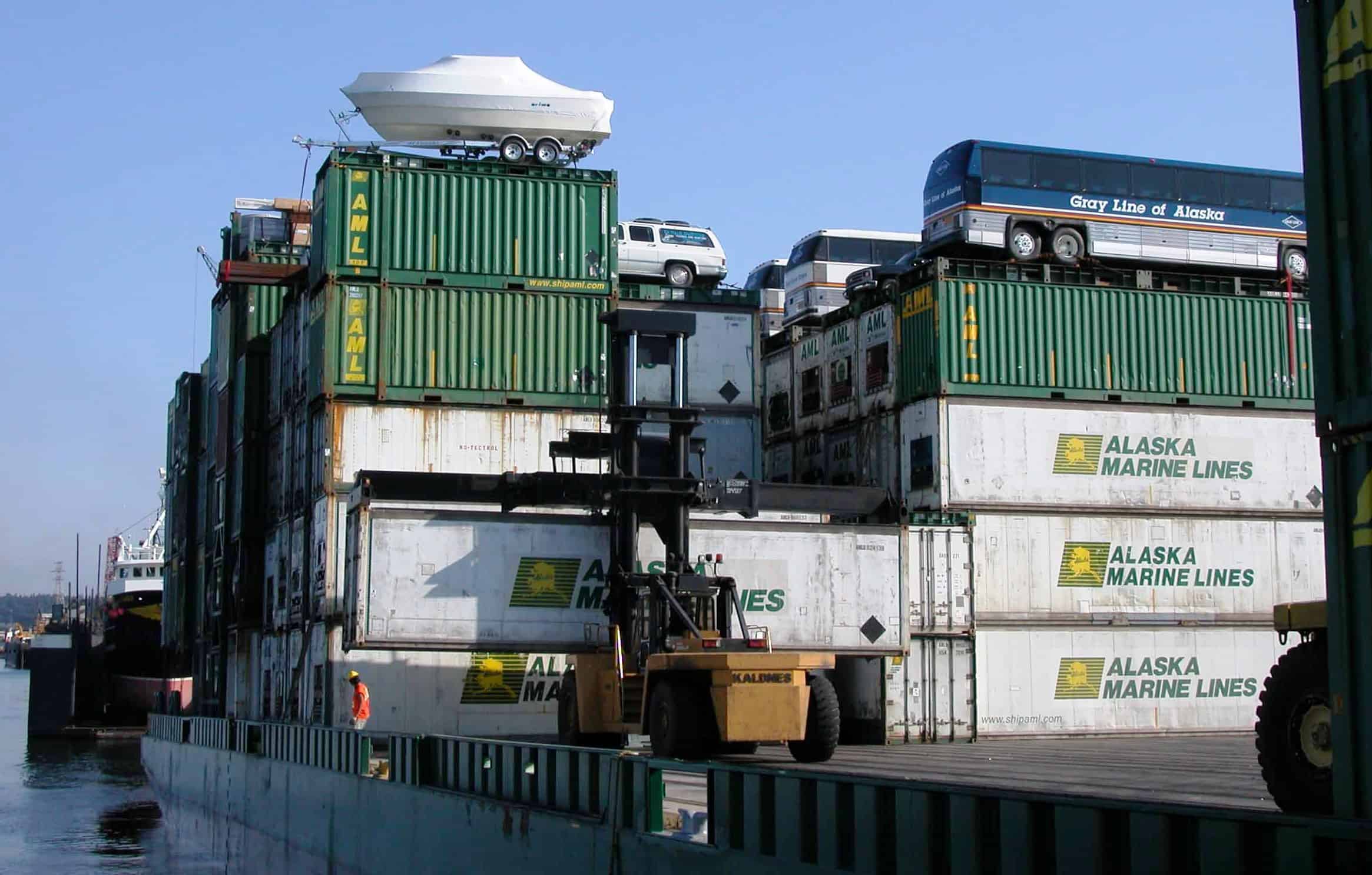
This photo was taken in 2003 from the Pacific Titan at the AML container facility on Seattle’s Duwamish River. The four Gray Line buses that went along for the ride were headed for Ketchikan, where a large increase in cruise boats was planned. Note the tall (and specialized) fork lifts, capable of sliding into the slots at the base of a container, lifting it, then lowering it to the ground for transport – each of the five cities in SE Alaska we stopped at there were at least two of these, and Cap’n Doug and his First Mate unloaded full containers, then loaded empty containers from a previous trip for shipment south to Seattle. This is an incredible way to supply a state that is virtually isolated from road and train access.
He also mentioned that he had 2.5 million pounds of salmon on board the barge that night – but due to a slow start to the fishing season, it’s barely a fourth of the total salmon tonnage heading to market in the Lower 48 for this time of year. As a matter of interest, 2.5 million pounds, at maybe an individual salmon average weight of, let’s say, 25 pounds, that’s 100,000 salmon! The containers on board Doug’s barge are double-sized, each holding 90,000 pounds of cargo, working out to about 28 containers filled to the brim with salmon (and that’s a quarter of his normal load). These are cold storage containers, each running refrigeration compressors, and every day he swings the tug around (180to tie up to the barge (out in open water), and his crew scrambles all over it to check to make sure everything is still running smoothly. The barge he tows typically carries 700+ containers, stacked 5-6 high, and oftentimes the top of the stack has vehicles that are more appropriate for a roadway surface.
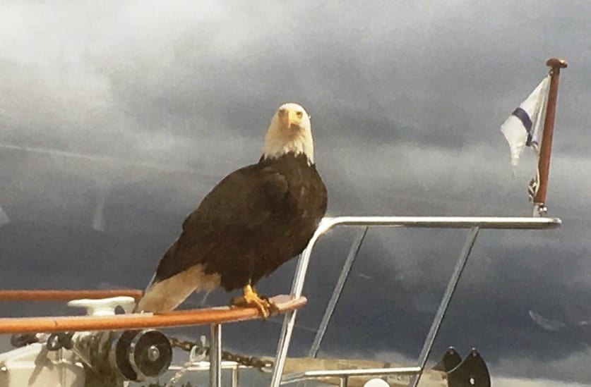
After our return to Shearwater from Discovery Cove, I dropped by Couverden moored at the end of the dock to say our temporary farewells to Steve and Andrea, as Kap and I were getting ready to head off in the morning. As we sat talking in their salon I spotted an eagle flying low and close to the side of their boat. Next thing I knew it had landed on the bow cap rail and I could clearly see it from my chair in the salon. I reached for my iPhone, but to my chagrin I had left it back at Flying Colours. I said to Steve – “Quick, grab your camera and get a photo of the eagle on your bow!” He went forward with his phone and snapped a bunch of photos. This is about as close as you get to a bald eagle without scaring it away. What a majestic bird!
Bald Eagle Territory. For such a powerful and majestic bird (and our national bird no less), the Bald Eagle emits a surprisingly weak and unmajestic call—usually a series of high-pitched piping notes – notes that sound quite wimpy. You can hear it at https://www.youtube.com/watch?v=9RArGl2vkGI. Throughout the Inside Passage you can hear Bald Eagles along the shore, particularly starting at Port McNeill. In Prince Rupert you can see Bald Eagles flying overhead almost all the time, and you can constantly hear their calls. Luckily, these calls are a good reminder for us to keep ZuZu under protection, as she’s the perfect size for a midday snack for the eagles around here.
A myth about eagle calls? What is your impression of what an eagle sounds like? I’ll bet it isn’t what you just hears. Nope, what most people think of as an eagle call is the result of dubbing a red-tailed hawk’s call for one into a John Wayne movie, where they didn’t think the actual call was good enough. Here’s the NPR segment about it: https://www.npr.org/templates/story/story.php?storyId=156187375, then click on the link three paragraphs into the PBS story.
Nearby is a photo from 2008 on the dock at Shearwater, with a bald eagle sitting on the sailboat spreader looking down at ZuZu, hoping for a quick snack.
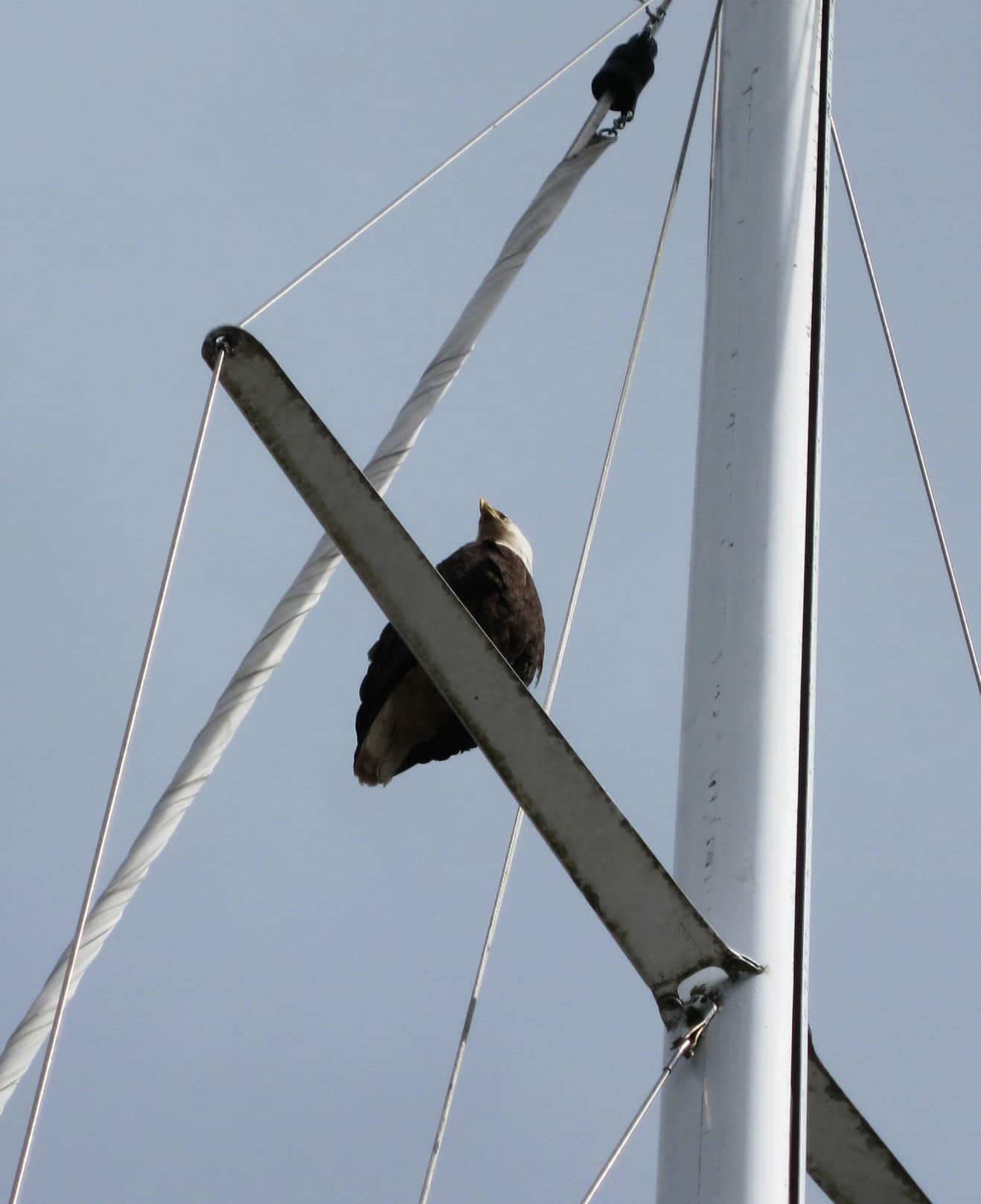
Here's a photo from 2008, looking up an an eagle perched on the mainsail spreader of a sailboat just across the dock from us. You could see the eagle's head cocked, looking down at ZuZu sitting on the deck of Cosmo Place, hoping to swoop down for a midday snack.
A close call with an almost ZuZu disaster from a bald eagle was in 2008 when we were laying over for the night at Shearwater on the way to SE Alaska. At the time we weren’t worrying about ZuZu making her security rounds on the teak cap rails – until Kap spotted this bald eagle sitting on the main mast spreader of a sailboat across the dock from us. He was close enough that we could see him/her cock the head so that an eye was looking directly down at ZuZu. In an instant the eagle could have swooped down, grabbed ZuZu by the talons and carried her away. An 8-9 lb cat would have been a small snack to that eagle. From that point on we’ve been very careful when and where we allow ZuZu in open areas on the deck – particularly if we hear any nearby eagle calls. We also have a habit of scanning nearby tree tops, and if we see any eagles, we keep ZuZu off the cap rails or the open main deck area of the bow.
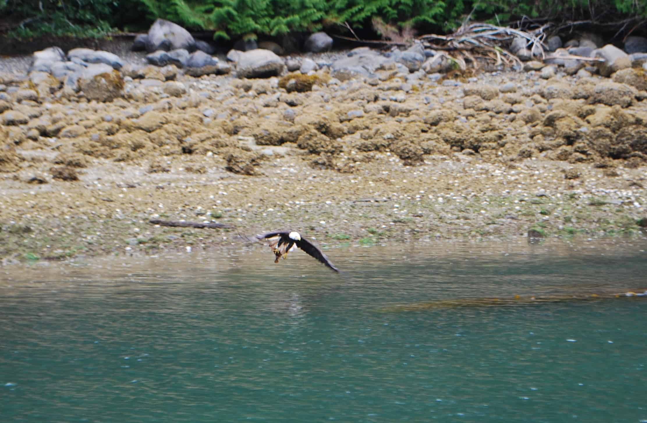
This photo was taken in the narrow Blow Hole Passage outside of Lagoon Cove, on shore just a couple dozen yards away. When I first spotted this bald eagle he/she had already plucked this 8” (or so) fish from the water and had deposited it in the shallows near the shore. When I looked over the eagle was hopping towards shore with the fish clutched by the talons. Just as we passed by the eagle took off with the fish held tight and flew right across our bow.
One sure way to attract eagles is to throw fish heads and entrails into the water as you’re cleaning your fish. As my photo at right attests, spotting eagles swooping in for their live prey near the water’s surface, we also see them in carrion mode just as often. At a sport fishing camp near Campbell River where we used to catch a ferry across from our moorage at April Point, we could watch eagles as long as we wanted at the fish cleaning station.
An even more unusual situation happened in early 2008 when we were getting some boat training prior to our departure for SE Alaska. We were in a small bay across Puget Sound from Seattle practicing anchoring techniques when we heard a loud commotion going on nearby. An eagle had dropped down on top of a duck – which we’d never before heard of as eagle prey – and with the duck in its talons the eagle was loudly flapping its wings, with water flying everywhere. Apparently the duck was too heavy for the eagle to take off, so it was bouncing up and down, flopping its way towards shore. Once on dry land – and with the duck still trying to escape – the eagle did what eagles do to kill their prey, most likely using its talons as deadly weapons. It was pretty unnerving to watch this happening just a few yards from us.
Next up: Slow Boat Home from Ketchikan.
Now that we’re back in better cell phone and WiFi range I’m finally able to get more up-to-date on my postings.
Ron